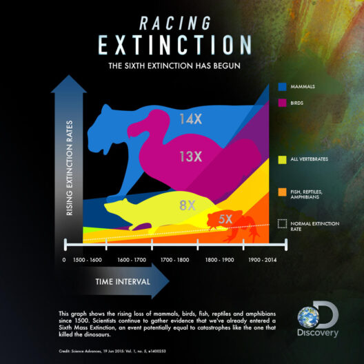


The phenomenon of climate maps is an intricate yet vital subject delineating the various weather zones on Earth. Climate maps serve as essential tools in understanding the diverse climatic conditions that prevail across different geographical locales. They employ a symphony of colors and symbols to portray intricate information about temperature, precipitation, humidity, and broader climatic patterns across the globe.
Definition of Climate Maps
A climate map is defined as a graphical representation that elucidates the climatic characteristics of a specific area or the Earth as a whole. These maps are meticulously crafted based on extensive meteorological data gathered over extended periods. Such data statistical in nature, encompasses variables such as average temperatures, precipitation levels, seasonal variations, and other climatic indicators. The intricate details encapsulated within these maps assist not only academics and meteorologists but also planners, environmentalists, and policymakers in devising strategic responses to climatic exigencies.
Types of Climate Maps
Climate maps come in various forms, each serving unique functions. The primary types are:
- Precipitation Maps: These maps delineate the average rainfall in specified regions over particular periods. They provide insights into wet and dry zones which are crucial for agricultural planning and water resource management.
- Temperature Maps: These illustrate average temperature distributions across regions. They can help forecast weather trends and assess the suitability of locales for different species and agricultural activities.
- Climate Classification Maps: These maps categorize regions into distinct climate types based on various classifications, such as Köppen climate classification. They help understand large-scale climatic patterns and their impact on biodiversity.
- Seasonal Maps: These represent climatic variations throughout different seasons, allowing for a comprehensive understanding of how weather patterns shift over time and geographic space.
Interpretation of Climate Maps
The interpretation of climate maps requires a fundamental knowledge of the symbols and legends used therein. Each color and icon represents specific climatic data, with warmer colors often indicating higher temperatures and cooler colors suggesting lower ones. Similarly, specific patterns may denote levels of precipitation, be it light, moderate, or heavy. Understanding these nuances is paramount for accurate and insightful analysis.
For instance, a precipitation map might show an area in shades of blue indicating a region with high rainfall, whereas nearby areas may appear in shades of yellow or brown, signaling arid conditions. Likewise, a temperature map may reveal tropical zones near the equator in vibrant reds, gradually shifting to cooler blues towards the poles. By examining these patterns collectively, one can gain a holistic view of global climate dynamics.
Impact of Climate Maps on Environmental Studies
Climate maps are indispensable in the study of climate change and its repercussions on ecosystems. They provide a foundational understanding of historical weather patterns, enabling researchers to detect anomalies and shifts caused by anthropogenic activities. The revelations drawn from these maps support environmental initiatives and research directed towards conservation and sustainability.
Furthermore, climate maps facilitate informed decision-making in urban planning and disaster management. By analyzing anticipated climate variations, planners can develop infrastructure that is resilient to extreme weather events. Consequentially, such proactive strategies can mitigate the impacts of floods, droughts, and other climate-induced disasters.
Technological Advancement and Its Role
With the advent of technology, the accuracy and accessibility of climate maps have evolved exponentially. Geographic Information Systems (GIS) now empower experts to overlay various data layers, unveiling complex interrelationships between climatic phenomena and geographic features. Satellite imaging augments this further, providing real-time data that enhance the precision of climate maps. Consequently, stakeholders can utilize these tools to anticipate climatic shifts and prepare for future scenarios effectively.
The Role of Education and Awareness
Climate maps are not solely reserved for scientists and policymakers. Public awareness is crucial. Educational initiatives can familiarize individuals with climate data and its relevance to their daily lives. Schools and community programs that emphasize the importance of understanding climate zones can inspire a generation of environmentally conscious citizens who recognize their role in combating climate change.
Moreover, integrating climate map literacy into educational curriculums can cultivate critical thinking among students. They can learn to analyze climatic data, recognize trends, and appreciate the urgency of environmental stewardship. Engaging the younger generation in these discussions fosters a sense of responsibility towards the planet.
Conclusion
Understanding climate maps and their pivotal role in revealing Earth’s weather zones is essential in addressing contemporary environmental challenges. These visual representations not only encapsulate complex data but also bridge the gap between scientific comprehension and public consciousness. As we grapple with the realities of climate change, climate maps serve as beacons of knowledge guiding us towards sustainable practices and informed decision-making. By embracing these tools and fostering awareness, we can navigate the shifting climates and forge a path toward a resilient future.