Understanding the intricate relationship between geography and weather presents a fascinating realm of study, one where the undulating contours of our planet interact with the atmosphere to produce an array of climatic phenomena. The geographic setting of a region significantly influences its weather patterns, impacting everything from temperature and precipitation to prevailing winds and climatic variations. These factors not only affect local ecosystems but also have broader implications for agriculture, urban planning, and disaster preparedness.
Geographical latitude is one of the primary determinants of climate. Regions situated near the equator, such as those in the tropics, typically experience warmer temperatures year-round, characterized by minimal seasonal variation. Conversely, locales positioned farther from the equator, such as polar regions, endure more extreme temperature fluctuations. The sun’s angle, which varies with latitude, plays a crucial role in the intensity of solar radiation received on Earth’s surface, leading to diverse weather phenomena across different regions.
The influence of altitude on weather is another significant factor. As elevation increases, temperature tends to decrease. This phenomenon can be observed in mountainous regions. High-altitude areas may experience alpine climates, with colder temperatures and variation in precipitation patterns compared to surrounding lowlands. Furthermore, mountains can affect wind patterns and create rain shadows; for instance, one side of a mountain range may receive abundant rainfall, while the opposite side remains arid.
Another pivotal aspect of geography affecting weather is proximity to water bodies. Coastal regions often experience milder climates than inland areas due to the heat-retaining properties of large water masses. Oceans and seas moderate temperatures, reducing temperature extremes and providing more consistent rainfall patterns. In contrast, areas far removed from the influence of oceans may see drastic temperature changes between seasons, exemplifying the critical interplay between land and water.
Topography also shapes local weather. Valleys, plateaus, and hills can create microclimates, small climatic areas with different weather characteristics than the surrounding region. For example, a valley may trap cold air, leading to cooler temperatures than nearby elevated areas. In contrast, hills can promote faster drainage of air, resulting in warmer conditions. Such microclimates can be essential for biodiversity, with unique flora and fauna adapted to specific local conditions.
The distribution of vegetation is integrally linked to climatic conditions, creating intricate ecosystems shaped by their geographic context. Forests, grasslands, and deserts all emerge in response to specific weather patterns. For instance, tropical rainforests thrive in regions with consistent rainfall and warm temperatures, while vast deserts exist in areas with minimal precipitation. Understanding these biome distributions provides insights into global biodiversity and environmental health.
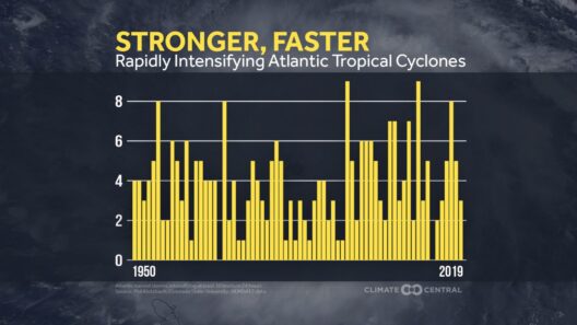
Weather patterns are also influenced by significant climatic systems, such as trade winds, which are established by the Earth’s rotation and varying solar heating. In tropical regions, trade winds contribute to storm formation, including hurricanes and typhoons. The geographical positioning of a region may render it more susceptible to these catastrophic weather events, raising concerns for coastal communities vulnerable to rising sea levels and storm surges.
As we consider the effects of geography on weather, it becomes increasingly clear that human activity intersects with these natural patterns. Urbanization, deforestation, and climate change have augmented the influence of geography on local weather. Cities, often referred to as urban heat islands, can experience elevated temperatures compared to surrounding areas due to concrete and asphalt absorbing and retaining heat. This phenomenon can exacerbate heatwaves, leading to higher energy consumption and increased health risks for residents.
In summary, the complexities of weather are deeply rooted in geographical variables. From latitude and elevation to proximity to bodies of water, each aspect contributes to a larger climatic puzzle. Understanding these relationships extends beyond mere academic inquiry; it is crucial for developing strategies to mitigate climate-related challenges. Harnessing knowledge about geography is essential for promoting sustainability, enhancing disaster preparedness, and fostering resilience among communities impacted by climate variability.
Moreover, as climate change continues to influence weather patterns globally, the need for localized knowledge becomes paramount. Adaptation strategies must account for the unique geographical characteristics that could significantly alter how different areas respond to climate impacts. By recognizing how geography shapes weather—and collectively acting upon this understanding—we can better safeguard our environment and respond to the challenges posed by a changing climate.
In conclusion, geography is a fundamental factor in shaping weather patterns. The interplay of latitude, altitude, proximity to water, and topography creates a multitude of climatic conditions across the globe. Recognizing these patterns is essential in addressing the ongoing effects of climate change and ensuring that communities can effectively respond to their surroundings. Elevated impact arises from a nuanced understanding of these geographical interactions, enabling informed discussions and actions toward a more sustainable future for all.


